We departed Needles CA this morning at 0857 hrs. The drive from Needles this morning was very scenic, with varying landscapes as we passed through desert, mountains and high plains. We started out at 495 ft at Needles CA (our GPS showed 559 ft) and we climbed as we headed east. The summit was at the Arizona Divide at 7335 ft down to 6909 ft at Flagstaff. Here are some pictures of the trip:
 |
| Flat and desert east of Needles |
 |
| Entering Arizona, and climbing! |
 |
| Desert with interesting rock formations in the background |
 |
| We continue to follow Route 66 into Arizona |
 |
| Approaching Kingman |
 |
| Totally different landscape |
 |
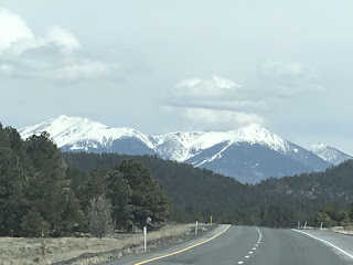
| Snowcapped mountains north of Flagstaff come into view. I believe it is Humphries Peak |
 |
| Snow along side the Interstate here. |
 |
| Passing the Arizona Divide at 7306 ft |
The RV Park is fairly spacious, with nice scenery in the distance.
After getting set up we had a late lunch and then headed east on I-40 to the Meteor Crater. It is about 5 miles south of the Interstate, and the red landscape like Sedona AZ is prevalent here.
About 50,000 years ago an iron-nickel meteorite travelling about 26,000 mph passed through our atmosphere and impacted earth. It created a crater 700 ft deep, 4000 ft across and 2.4 miles in circumference. They built a visitor center adjacent to the crater which has a movie, and discovery center, viewing areas, guided tours, a gift shop, etc. Here are some pictures:
 |
| The Visitor Center |
 |
| The bottom of the crater |
 |
| Doreen walked down to one viewing point. |
 |
| Various layers of rock exposed. |
We then went inside and walked through the Discovery Center. There were many displays to help you understand meteors, craters etc.
 |
| Inside the Discovery Center |
 |
| Original exploration of the crater |
 |
| An aerial view |
Outside there is an Apollo Test Capsule, used to train astronauts.
 |
| Petrified wood |
 |
| More petrified wood |
 |
| The barracks used by the employees. We are so far from anything here they stay right on site. |
 |
| Doreen bought me a souvenir from the gift shop. A Route 66 bottle beer koozie! |
While we are here, I have an appointment for the truck to get some routine maintenance done as well as a recall and a re-attack on the squealing noise which is still very intermittent.
Stats Update:
Campsite#: 23 of 27
# States Traveled Through This Trip: 12
Baseball Parks Visited So Far This Trip: 6 (Houston, Corpus Christi, Arizona X 3, San Diego)
Point to point travel miles: 4803 miles
- Avg point to point travel miles: 209 miles
Vicinity miles: 4173 miles
- Avg vicinity miles: 190 miles
Total miles driven: 8976 miles
Total point to point driving time: 94 hrs 29 minutes
Total fuel purchased: 787.288 gals
Total fuel cost: $2261.54
Average fuel cost: $2.954
Max fuel cost: $3.999 (Seal Beach CA)
Min fuel cost: $2.279 (Wharton TX)
Average MPG: 11.49 miles/gal
# Nights at end of this stay: 128
Lodging cost: $4365.00
- Average lodging cost/night: $34.10/night


3 comments:
Ed,
Wow -good travel records.
If you get back to Calif here are some tips on buying fuel.
Always top off in Arizona or Nevada before entering Calif. When leaving try and get to Nevada or Calif as near to empty as you can then fill up. Calif is now full of tax hungry democrats and the gas tax is their favorite weapon.
Use the App called "Gas Buddy" it will give you prices on gas in the vicinity of where your at. You can also look ahead and enter your future location to investigate fuel costs.
You might look into a Costco card in the future. Costco in Irvine has diesel at $3.599 this morning. Also, with a Costco Visa you get a 4% rebate back on fuel.
Rick
Thanks, Rick! I use Gas Buddy a lot on the road. It is surprising how prices vary a lot in a small distance. The State fuel taxes really make a huge difference in prices.
Ed
Post a Comment